Highlights
-
•
Post-construction of the Bisalpur Dam, a marked decrease in peak discharge was observed, with the MK/MMK statistics indicating a Zc value of −3.24 and a Pc value of 0.001. The Sen's Slope was −21.51 MCM/year.
-
•
Before the Dam's construction, the peak discharge reached a maximum of 7680 MCM in the 1981-82.
-
•
The water level at the gauge station significantly decreased, with MK/MMK statistics showing a Zc value of −3.46 and a Pc value of 0.001, declining at an annual rate of −0.035 m/year.
Abstract
The construction of large-scale infrastructure projects like dams can substantially alter local hydrological systems, prompting concerns about their impacts on river water levels and discharge. This study was undertaken in response to the compelling need to investigate and analyze the potential implications of water scarcity, particularly within the framework of the Bisalpur Dam located on the Banas River. This study uses non-parametric trend analysis tests - Mann-Kendall (MK) and Modified Mann-Kendall (MMK) for river discharge and water level trend analysis, and Sen's Slope and Pettit's test for detecting changes or trends. Significant shifts in these parameters were identified post-construction. From 1960 to 2011, the Dam's construction led to a marked decrease in peak discharge (MK/MMK statistics Zc = −3.24; Pc = 0.001), with a Sen's slope of −21.51 MCM/year. Before the Dam's construction, the peak discharge reached a maximum of 7680 MCM in 1981–82. The gauge station's water level significantly decreased (MK/MMK statistics Zc = −3.46; Pc = 0.001) at an annual rate of −0.035 m/year. This level, peaking at 201.59 m in 1981–82, declined from an average of 196.04 m–194.5 m post-construction. The findings underscore the extensive impact of dam construction on local hydrological parameters. These results hold significant implications for future infrastructure projects, emphasizing the critical need for comprehensive environmental impact assessments to be conducted before project implementation. This understanding can aid in designing interventions with reduced environmental impacts, leading to more sustainable infrastructure development.
Keywords
Bisalpur dam
Banas river
Water levels
Discharge
Impact analysis
Hydrological changes
Sustainable water management
1. Introduction
In recent years, anthropogenic activities, notably dam construction, have significantly transformed riverbed dynamics, impacting rivers' hydrological, physical, chemical, and biological attributes [1]. Dams are essential hydraulic structures for water resource management and energy storage and have significant economic and political importance [2]. Dams, essential for power generation, water resource utilisation, navigation, and flood control, have emerged as pivotal elements in societal development [[3], [4], [5]]. However, their construction often results in profound alterations to natural river systems, affecting water and sediment transport processes, flow variation, sand loss, and habitat degradation [6]. The transformation of river systems by dams has been documented globally, with large rivers in East, Southern, and Southeast Asia experiencing substantial reductions in annual sediment fluxes and widespread river disconnections [7]. While dams serve critical civilizational needs, they also modify downstream water and sediment fluxes, altering river evolution processes and contributing to ecological changes [8,9]. Climate change further exacerbates these effects, influencing runoff and sediment yield in watersheds. Despite existing studies on dam-induced hydrological changes and their ecological consequences, there remains an urgent need for more comprehensive research, especially in sustainable water management [10]. The Rur Dam in Germany and the Shuikou Dam in the Minjiang River are prime examples of how dam construction can drastically alter river flow and sediment dynamics, leading to significant environmental and ecological impacts [11,12]. Arantes et al., 2019 Emphasizes the influence of hydroelectric dams on tropical river fish, which impacts species adapted to fast-moving waters, resulting in reduced fishery production and ecosystem benefits. It focuses on utilizing fish characteristics to enhance the prediction and management of these impacts [13]. Hasan et al. (2023) investigated the influence of changes in land use and land cover (LULC) on flooding in the Jamuna River between 1990 and 2020. The researchers employed advanced techniques and discovered noteworthy connections, particularly in remote regions, emphasizing the significance of localized flood management [14]. Saikia et al., 2022 investigated the impact of precipitation patterns and geophysical factors, such as tidal and river levels, on the inflow volumes of wastewater treatment plants. Employing an innovative method, it determined that these parameters substantially impacted the daily and monthly inflow volumes. The findings contribute to developing long-term strategies for managing wastewater and adapting infrastructure [15]. Mehta et al., 2023 enhanced flood prediction at Sardar Sarovar Dam by utilizing hierarchical clustering and Thiessen polygons to identify crucial rain gauge stations. The analysis focused on rainfall data from 2010 to 2018. The HEC-HMS model validated the rain gauge network's effectiveness and improved flood forecasting accuracy. This highlights the significance of strategically placing rain gauges for efficient flood management [16]. Recent studies emphasize the varied impacts of dam construction on river ecosystems. An approach utilizes 33 Indicators of Hydrologic Alteration (IHA) and 34 Environmental Flow Components (EFC) based on hydrological frequencies to assess the daily discharge variations after dam construction, highlighting the intricate nature of hydrological systems [17]. A study in the Mekong River Basin uses an agent-based model to evaluate the effects of dams and climate change on hydro ecological conditions (HEC) and natural hazard risk (NHR). The study highlights a significant sensitivity to changes in precipitation, particularly upstream [18]. Recent research has significantly enhanced the understanding of the resilience of hydraulic structures and the management of river basins. A study on the failure patterns of gravity dams under downstream blast loading revealed consistent damage mechanisms across different scales and detonation intensities. This finding underscores the importance of similarity principles in assessing dam infrastructures' safety and structural soundness [19]. Simultaneously, another study concentrated on enhancing flood prediction in the Narmada river basin by utilizing hierarchical clustering and Thiessen polygon algorithms. This method has significantly improved the accuracy of rainfall-runoff models at the Sardar Sarovar Dam, representing a substantial advancement in predictive precision [20]. In their 2019 study, Kuriqi et al. assess the impact of flow regimes on e-flows and hydropower in the Iberian Peninsula, using hydrological models and e-flow methods. Findings reveal that energy output varies across regimes, with pluvial stable sites being consistent, while pluvio-nival sites are unstable. The study underscores the importance of dynamic e-flows for sustainable hydropower and ecosystem health [21]. Furthermore, another study utilizing remote sensing and statistical techniques has provided insights into the flood risks facing Bihar's Ganga River. The results emphasize large flooded areas and emphasize the urgent need for sophisticated flood management techniques to reduce the effects of these natural disasters. The studies highlight the significance of using innovative methods and interdisciplinary strategies to improve the safety and sustainability of water resource management practices [5].One study focusing on the Komardanga Dam and Barrage has shown that despite consistent rainfall patterns, damming and water diversion activities have significantly transformed wetland ecosystems. This alteration has transitioned these areas from being frequently to sparsely inundated, promoting agricultural reclamation at the expense of wetland integrity and socio-ecological balance [18,22]. A study near Ithaca, NY, USA, shows that dam reservoirs act as long-term sinks for microplastics, with significantly higher concentrations in the sediment within reservoirs, highlighting the role of dams in global riverine microplastic transport [23].Lastly, the impact of Manwan and Dachaoshan Dams on the Lancang River's water quality and self-purification capacity indicates initial quality deterioration followed by improvement. The study notes the dams' varied effects on water quality and self-purification across different river segments, underlining the need to consider the intricate effects of dams on aquatic ecosystems [24]. In their 2020 study, Kuriqi et al. explore the impacts of environmental flow methods on hydropower efficiency and river ecosystems at run-of-river hydropower plants in the Tagus basin, focusing on the native Iberian barbel fish. This research, utilizing hydropower, hydrologic, and ecohydraulic models, aims to balance hydropower production with environmental sustainability across different flow regimes [25]. Najafzadeh et al., 2023 study evaluates the uncertainty in AI models (GEP, MT, MARS) for streamflow forecasting, finding Model Tree (MT) as the most accurate with lower uncertainty (95%PPU = 0.59, R-factor = 1.67). Their research highlights the need for advancements in AI to improve streamflow prediction accuracy [26]. The World Commission on Dams (2000) thoroughly examines the advantages and difficulties linked to dam developments worldwide 18]. Vörösmarty et al., 2010 highlight that around 80% of the global population faces significant risks to water security. This highlights the immediate necessity to tackle the diverse range of demands on freshwater supplies, considering both the human and ecological aspects [27]. Poff et al., 2010 highlight a significant finding: 92% of the studies examined revealed negative environmental consequences resulting from changes in water flow. Emphasize the wide range of ecological reactions observed in various groups of organisms (such as macroinvertebrates, fish, and riparian vegetation) and different types of responses (including changes in abundance, variety, and demographic characteristics). This underscores the widespread and varying effects of flow modification in river ecosystems [28,29]. Grill et al. (2019) have identified dams and reservoirs as primary factors causing the decline in river connectivity, which in turn has negative impacts on ecological processes, biodiversity, and the services provided by freshwater river systems (FFRs) [30].
The primary hypothesis posited in this study is that the construction of the Bisalpur Dam has led to significant hydrological alterations in the Banas River. These alterations are manifested in reduced peak discharge and lower water levels, which have potential long-term implications for local and regional water resource management. Recognizing these challenges posed by the Dam, the present study focuses on the Bisalpur Dam's construction and its impact on the water levels and discharge of the Banas River over 60 years. Employing non-parametric tests such as the MK test and MMK test, Sen's slope estimator, and Pettitt t-test, this study aims to provide a detailed analysis of the river's hydrological parameters and their changes post-dam construction. The research hypothesis posits that the construction of the Bisalpur Dam has led to significant hydrological alterations in the Banas River, with potential long-term implications for local and regional water resource management. This study's novelty lies in its focused examination of a six-decade-long impact of dam construction on a specific river system, providing insights that contribute to the broader understanding of how such infrastructural projects influence river hydrology. By highlighting the Bisalpur Dam's effects, this research underscores the critical need for comprehensive environmental impact assessments and sustainable water resource management strategies in the face of large-scale infrastructural interventions. Additionally, the contribution of this review lies in synthesizing and critically analyzing existing literature on dam-induced hydrological changes, providing a comprehensive overview of the global context, recent advancements, and key challenges in this field.
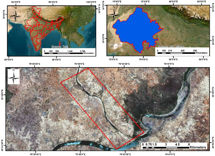
1.1. Study area
The Banas River is the main focus of this study, is represented in Fig. 1. Its role as an ecological and socio-economic cornerstone in Rajasthan. Its significance extends beyond mere geographical relevance, serving as a crucial empirical prism to examine the intricate interplay between extensive infrastructural development and riverine systems. The well-being and uninterrupted flow of this river constitute a fundamental linchpin in the sustenance of livelihoods within the region. Notably, the district of Tonk relies extensively on the Banas River for agricultural irrigation and potable water, underscoring its indispensability. Amidst the semi-arid to arid landscapes characterizing this district, the river emerges as a paramount factor, profoundly influencing agricultural viability and proffering economic stability to local communities. Understanding the consequences of the Bisalpur Dam on the Banas River's hydrology is essential, as it is representative of the broader impact that such infrastructural projects can have on a river's natural course and the well-being of dependent populations. Fig. 2 shows the river Stream flow of the Banash River and the Sub-Basin of the Bishalpur Dam. The rainfall and runoff data of the sub-basin area are used for the study. Fig. 3shows the precipitation and runoff pattern Sub-Basin. This data is crucial in tracing the hydrological shifts since the Dam's construction and anticipating future changes (see Fig. 4).
 Fig. 1
 Fig. 2
 Fig. 3
 Fig. 4
The Banas River's diverse course through the Aravalli Range, Mewar Plains, and Chambal Valley, encompassing geological epochs from Archaean to Quaternary formations, forms the backdrop of this study. Its hydrology, shaped by concentrated monsoon rainfall, sets the stage for examining the impact of the Bisalpur Dam—a significant human intervention—on the river's hydrological dynamics. This study aims to analyze how the Dam has altered the discharge and water level of the Banas River, offering insights into the river's future and implications for sustainable water resource management in the region.
2. Materials and methods
2.1. Datasets
This study collected the recorded discharge and water level datasets from the Banash River gauge and discharge site at Baranwada from 1960 to 2012. This data is a crucial parameter that provides insights into the river's capacity to support various ecosystem services, such as irrigation, drinking water supply, and aquatic habitat. The dataset of discharge and water level information is within the same timeframe. The water level data and discharge data served as a foundational basis for our understanding of the hydrological changes in the Banas River after the construction of the Bisalpur Dam.
2.1.1. Uncertainty analysis
The histogram showcases the distribution of simulated mean discharge values for the Banas River, derived from a Monte Carlo simulation approach to model the impact of the Bisalpur Dam on river discharge. The simulation generates a range of discharge values, reflecting the inherent variability and uncertainty in hydrological data.
The magenta dashed lines mark the 95% confidence interval, indicating the range within which 95% of the simulated discharge values are expected to lie. This interval is crucial for understanding the uncertainty in river discharge projections and is vital for effective water resource management and planning under varying hydrological conditions.
The Monte Carlo simulation employs the following equation to generate simulated discharge values [31]:
This methodological approach allows for a comprehensive analysis of the potential variations in water quality and river discharge [32], highlighting the effects of infrastructure projects like the Bisalpur Dam on the hydrological regime of the Banas River.
2.2. Methods
This study extensively examines the hydrological patterns exhibited by the Banas River over time, with a primary emphasis on evaluating the occurrence of water scarcity attributed to dam construction. Fig. 5 shows the methodology flow chart utilized in this study, elucidating the sequential steps employed to analyze the Banas Rivers. This analytical framework specifically targets and explores the ramifications of dam construction in the regional context of water scarcity.
 Fig. 5
This methodology entailed a comprehensive analysis of two primary water level and discharge data from the Baranwada G&D site between 1960 and 2010. The first dataset comprised essential discharge data, a parameter for assessing the river's capacity to sustain various ecosystem services, including irrigation, potable water supply, and aquatic habitats. The second dataset consisted of water level information, complementing the discharge data and forming the fundamental basis for comprehending the hydrological dynamics of the Banas River. This methodology commenced with the identification of significant trends within the datasets. The Mann-Kendall (MK) test is a widely utilized non-parametric method for assessing trends in time-series data. Equation (1)represents the Mann-Kendall test statistic.(1)
The analysis also employs the MMK test in this study. The MMK test handles serial correlation, ensuring more accuracy and reliability of the trend detection. These trend identification, which proceeded with polynomial fitting, explicitly applied a first-degree polynomial (linear) equation to the data. This was accomplished using the polyfit function from the NumPy library. Equation (2) is the general form of a first-degree polynomial equation:(2)
To quantify the identified trends, the Sen's Slope Estimator, a robust method resistant to outliers, was employed, providing reliable estimates of the rate of change—additionally, the Pettitt test to detect significant change points in the time-series data. Change points signify notable shifts in the river's hydrological dynamics, which may be attributed to climatic or anthropogenic factors.
The assessment of water scarcity was a critical aspect of our methodology. Water scarcity is also evaluated by examining the trends in discharge data and their implications for water availability. By integrating water level data and discharge trends, the river's capacity to meet the demands of various water-related services, particularly in the face of changing hydrological patterns.
By applying this comprehensive methodology, it not only detected and quantified significant trends in the Banas River's hydrological parameters but also assessed the implications for water scarcity due to the construction of the Dam. These findings provide valuable insights into the river's hydrological behaviour and responses to human interventions, facilitating informed decisions in sustainable water resource management and addressing the pressing issue of water scarcity.
This study faces a notable limitation concerning the availability of comprehensive long-term and real-time hydrological data. The discontinuation of data collection at this critical site limits the scope of our predictive analysis, impacting the reliability and accuracy of our projections regarding future hydrological conditions of the Banas River. This limitation underscores the need for sustained and systematic hydrological monitoring, especially in evaluating the impacts of significant infrastructural developments like dam construction on river ecosystems. Enhanced understanding and assessment in this area would benefit greatly from the continuation and regularity of data collection efforts, enabling the accumulation of a detailed dataset for in-depth analysis and modelling.